Image annotation, the process of labeling objects and features within images, is a critical component in training artificial intelligence models. When applied to aerial imagery, it unlocks a world of possibilities for industries ranging from agriculture and urban planning to disaster response and environmental monitoring.
The Importance of Aerial Image Annotation 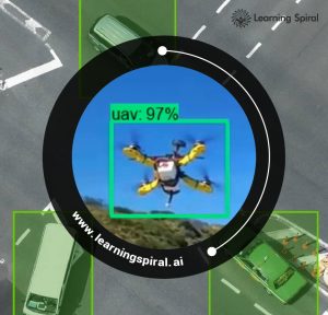
Aerial images, captured from drones, satellites, or airplanes, offer a unique perspective on the world. By annotating these images, we can extract valuable information that would otherwise be difficult or impossible to obtain. Some common applications include:
- Object Detection: Identifying objects like vehicles, buildings, and trees within aerial images is essential for tasks such as traffic monitoring, urban planning, and disaster assessment.
- Land Use Classification: Categorizing different land cover types, such as forests, agricultural fields, and water bodies, is crucial for environmental monitoring, climate change studies, and precision agriculture.
- Change Detection: Comparing annotated aerial images over time helps identify changes in land use, infrastructure, or natural disasters.
- Object Tracking: Tracking moving objects like vehicles or animals in aerial videos enables applications like traffic analysis, wildlife monitoring, and surveillance.
Challenges and Considerations
While aerial image annotation offers immense potential, it also presents unique challenges. Some of the key considerations include:
- Image Resolution: Aerial images often have high resolutions, making it challenging to accurately annotate small objects or details.
- Data Volume: The vast amount of aerial imagery generated requires efficient annotation processes and tools.
- Annotation Complexity: Complex objects and scenes, such as urban areas or dense forests, demand sophisticated annotation techniques.
- Data Accuracy: Ensuring the accuracy of annotations is critical for the performance of AI models.
The Future of Aerial Image Annotation
Advancements in technology are continually expanding the possibilities of aerial image annotation. We can expect to see:
- Automation: Increased use of AI-assisted annotation tools to improve efficiency and accuracy.
- 3D Annotation: Moving beyond 2D annotations to capture depth information for applications like autonomous vehicles and virtual reality.
- Real-time Annotation: Enabling real-time analysis and decision-making through rapid image annotation.
- Integration with Other Data Sources: Combining aerial imagery with other data types, such as LiDAR or ground-level sensors, to create more comprehensive datasets.
As aerial image annotation continues to evolve, it will play an increasingly vital role in addressing global challenges and driving innovation across various industries. By harnessing the power of annotated aerial data, we can unlock new insights, optimize processes, and make informed decisions.
Would you like to know more about specific use cases or the tools used for aerial image annotation? Learning Spiral has a variety of use cases fit for several applications under text, image, and video annotation. So, comment below and let us know what to cover next.