Learning spiral has a workforce with a diverse set of skills that has a Rich history of handling sensitive and large amounts of data that lead us to the ability to deliver data annotation and data labeling on-demand and at scale. Learning Spiral, with 15+ years of experience with international clients possesses immense domain knowledge under strict NDA and SLAs. We provide skilled professionals for high-quality data annotation/labeling solutions with scalability, flexibility, and high standards of security. We provide annotation services as our data annotation team is capable of drawing bounding boxes, cuboids, polygon, image classification/ tagging, text annotation, image masking annotation, data annotation & labeling, 2D & 3D annotation, Semantic segmentation, 3D LIDAR Annotation, autonomous vehicle, tagging of aerial view pictures, drone technology, contour annotation, etc. Data annotation consists of text annotation, image annotation, and video annotation using the various techniques and expert-designed tools as per the project requirements and machine learning algorithms compatibility. Data annotation is done to create the training data sets for AI and ML. Learning Spiral is partnering with some of the leading global companies focusing on AI initiatives, in the world, and is working on a wide variety of highly nuanced Computer Vision, NLP/NLU, Content and digital publishing use cases. Working with utmost accuracy for Lidar Point Cloud Segmentation projects. The majority of the work we perform is using human intervention by trained, in-house & dedicated professionals.
What is Lidar Annotation
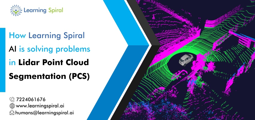
LIDAR stands for LIght Detection and Ranging. It is a land surveying method that uses remote sensing technology emitting light that travels around the object and back to the receiver creating points every time it hits the object building a 3D map of the entire scene. We help annotate or label cars, pedestrians, bicyclists, trees, animals, traffic lights, billboards, garbage bin, etc in this map by drawing bounding boxes or cuboids precisely to train the machine learning algorithms to interpret the world. In short LIDAR Annotation: Identifies objects in a 3D point cloud and draws bounding cuboids around the specified objects, returning the positions and sizes of these boxes.
Point cloud segmentation (PCS)
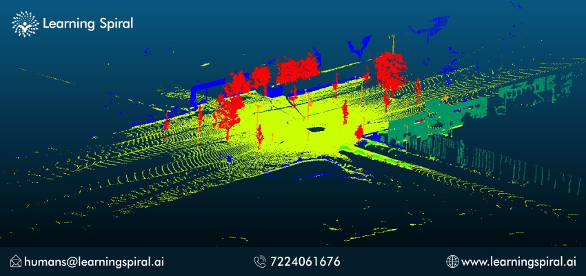
3D point cloud segmentation is the process of classifying point clouds into multiple homogeneous regions, the points in the same region will have the same properties. The segmentation is challenging because of high redundancy, uneven sampling density, and lack of explicit structure of point cloud data.
Semantic scene understanding is important for a variety of applications, particularly autonomous driving. Rigorously tested by a handful of Scale’s customers during a private beta, Sensor Fusion Segmentation annotation provides fine-grained understanding of surfaces and objects in a 3D point cloud
How learning spiral is helping their clients with PCS project
We Perform every process Step by Step
The segmentation of point clouds into the foreground and background is a fundamental step in processing 3D point clouds. Given the set of point clouds, the objective of the segmentation process is to cluster points with similar characteristics into homogeneous regions. These isolated regions should be meaningful. The segmentation process could be helpful for analyzing the scene in various aspects such as locating and recognizing objects, classification, and feature extraction.
We Label with utmost accuracy to get accurate results
We label vehicles, traffic lights, signs with appropriate attributes, pedestrian, vegetation, etc
Types of vehicles car, bus, emergency vehicles
Constructed cones, animal, motorbike, cycle, cyclist
We do segment point cloud efficiently for all our clients through following steps
Understanding the Road
Learning Spiral creates high-quality training datasets and validation data to enable automotive companies to develop with confidence computer vision and machine learning models that reliably and safely power autonomous vehicles. With the LiDAR annotation process, we help autonomous vehicles understand the environment more precisely.
Ground Truth Annotation Quality
Achieve the most reliable safety standard and the best results by training and validating your algorithms with accurate annotations made by highly skilled professionals.
Fast and flexible scalability
Our fast and user-friendly system is flexible in its approach. Manage projects with ample numbers of annotated images faster than conventional approaches.
Real-world Scenario Generation
Challenge your driving functions with edge-case scenarios derived from real-world recordings directly in your simulation. We help you achieve more complete coverage of the enormous test space through meaningful variations of the base scenarios through LiDAR annotations.
To Scale your machine learning program quickly and improve user experiences with high-quality, human-annotated data and to provide the best Data annotation services including LIDAR Annotation and labeling services.
Tell us about your Data Labeling and Data Annotation needs and we will build a dedicated team that fits you perfectly.